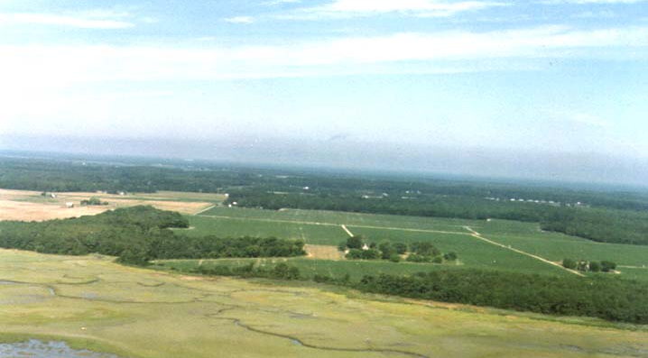

This was taken a lot of years ago. To make my excuses to Will I was flying with my right hand an snapping pictures with my left hand.
The plane is heading a little North of West I'm just finishing a turn
from base to final to shoot a landing on the driveway almost directly
ahead of me. The wind must have been from the West, not the best
direction to land as its over the trees and then the drive way runs
downhill to route 700 the seaside road. What I usally do is go in this
way check the wind down low, abort and land downwind from west to east,
the lesser evil. No matter it must have worked out ok because here I am.
The picture is taken from about 800 ft. agl over Ramshorn Channel about halfway between Oyster and Eastville on the Seaside. Just north of that brown piece of ground in the center of those trees is the house "Sealand" where I grew up. I long ago sold the house and 8 acres of yard which I am aiming at.
In the foreground are the flats and marshes of the seaside, and you can see some of the thousands of miles of creeks (they appear as little rivers to you non residents) but I like creeks. The haze line between land and sky marks the Cheaspeak Bay so it gives an idea of how narrow Nothampton is. To the left top you can see a little steak of water That would be Cherrystone Creek area of John Wilkins' bayside patent and neighbor to Obedience Robins. The little row of dots to the right would be Eastville .
From the ground color it's late spring on the Eastern Shore.
by Bill Wilkins
Return to the top of this page.
Return to the School Photo Album page.
Return to the GHOTES home page
Copyright © 1996-97 Most recent revision December 21, 2003 (wls)